 Kyle and team mates on the sidelines We travelled from San Antonio to Seguin (40 miles east of San Antonio) today to meet friends Phil and Michelle Garoni and daughters Kelsey and Karina to see the football game between Trinity University and Texas Lutheran University. Phil and Michelle's son Kyle is an offensive guard for Trinity, located in San Antonio.
We greatly enjoyed the game (TLU won unfortunately), and afterward we went out for a Texas dinner at Josephine's in San Antonio. Thanks to Phil and Michelle for sharing your family day with us!
 Phil, Kyle, Karina, Kelsey, and Michelle Garoni after the TLU game
 The Alamo Today we did a walking tour of downtown San Antonio. Our first stop was the Alamo, where Davy Crockett, Jim Bowie, Colonel Travis and 186 other brave men sacrificed their lives fighting for Texas Independence. It was inspiring.
We were impressed by the beautiful River Walk which winds through the downtown. In the 1930's a local architect had the vision to dredge channels and build a series of locks. The result is a waterway lined by stunning stonework and tropical gardens. The walkway along the edge of the water is lined with restaurants and boutiques.
San Antonio is a beautiful city and we are looking forward to more exploring tomorrow.
 San Antonio River walk scene  Ducks with reflected umbrellas, River walk, San Antonio  San Fernando Cathedral, where the remains of Davy Crockett and the other Texas heroes are interred
 Wind generators north of Lubbock Today was a travel day. We drove for seven hours from Lubbock to San Antonio. The first part of the drive was through cotton and oil fields, then we drove through an immense wind power generating area. The wind generators stretched for miles and miles. The second part of the day was through rolling, forested hills. The land is arid, but there is a variety of trees: stubby oak, juniper, and pine. It seemed odd to see wildflowers blooming in October. There were huge ranches all through this area, all marked by attractive gates displaying their name and brand.
At Junction, we stopped for a lunch of Texas BBQ. There were autographed pictures of Willie Nelson and Whoopie Goldberg with the restaurant's owner on the wall!
We are planning to stay in San Antonio for four nights, so we will have time to explore the many sights. Our hotel is within walking distance of the Alamo and the Market Square. This evening at dusk tens of thousands of small black birds called Grackles came flying into the tree tops in the streets around our hotel. It was quite a sight and the sound of the birds was almost deafening. Bob is going to try to figure out a way to video and perhaps record the sound tomorrow evening.
Trip Mileage: 4364 miles
 Ranch west of Lubbock As we crossed into Texas the landscape became more prosperous. We drove through oil fields and past cattle ranches. The major crops around Lubbock include cotton and peanuts. Most of the crops are irrigated from groundwater. The cotton fields were white with the cotton that is ready to be harvested. We learned that when the cotton is ready, the fields are defoliated so all that remains are the cotton bolls. Then they drive down the rows with a combine that combs the cotton off of the stalk. Once the cotton is picked, the plant is dead. New cotton plants are planted in the spring.
This evening we visited with our friends Mac and Linda McBroom, who live in Lubbock. They gave us a tour of the city including the beautiful Texas Tech campus and the grand homes of the cattlemen, many of which have been designated as historic buildings. We were very impressed with Lubbock. It is prosperous and growing and has a very dynamic energy. The city planners have been thoughtful about the development of the city including bylaws about signage. The houses and many of the larger buildings are built of brick in order to withstand tornadoes. Not only are the homes resistant to the tornadoes, they are very attractive. In 1970, Lubbock was hit by a huge tornado that did a tremendous amount of damage to the city. Mac and Linda showed us the tornado shelter they have in their back yard.
Mac and Linda treated us to a delicious dinner at their favourite Italian restaurant. It was great to see them and to meet their daughter and grandson. We thoroughly enjoyed our visit.
Trip Mileage: 3957 miles  Cotton ready for harvest, west of Lubbock
 Roswell mural We had a good view of the city of Albuquerque this morning as we drove through and it broadened our perspective. In contrast to the 300 year old pueblos in Old Town, the downtown of the city has modern skyscrapers. This week is the Balloonist Festival in Albuquerque. There was a mass launch just as we were driving through and we could see hundreds of hot air balloons rising into the sky - quite a sight. Our elevation stayed between 6 000 and 7 000 ' for most of the day. The landscape was flat and arid with vegetation varying from cactus to forests of squat pine and cedars to grasslands. The parts of New Mexico that we have seen are not particularly prosperous. We turned south on the 285 at Clines Corners. For the next 130 miles we drove through a vast expanse of grassland. There was no sign of human settlement for mile after mile. The only animals we saw were antelope and ravens which seem to thrive in this environment. There were three towns marked on the map. Two were derelict ghost towns; one was just an old empty gas station. Towards Roswell as we lost elevation, we could see cattle and sheep as well as irrigated fields. According to the local Visitor's Guide, the main sectors of the economy are oil and gas exploration, agriculture and dairy and manufacturing. Agriculture includes cattle ranches, cotton and chile farms and dairy farms. The world's largest mozzarella cheese producing plant is at Leprino Foods, in Roswell. This week Roswell is hosting the State Fair, so the city is bustling. Roswell is also famous for the International UFO Museum and Research Centre. It is a non-profit museum dedicated to exploring UFO's and extraterrestrial phenomena. It was founded by eyewitnesses who were involved in the 1947 Roswell Incident, the crash of an alleged "flying saucer" on a ranch near town. We spent an hour looking at the evidence and the archive of photos and eyewitness accounts. The museum has a website, www.roswellufomuseum.com. The town has capitalized on the UFO/Alien theme as an attraction for tourists. The street lights are designed to look like alien heads that glow in the dark and most of the store front displays incorporate little green men of some sort or another. The high school team is the Rockets. Trip Mileage: 3778 miles 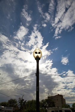 Streetlight, Roswell, NM
Our route continued through the high desert. When we crossed the Continental Divide just east of Gallup the elevation was 7 300'.
We spent the afternoon exploring the Old Town market in Albuquerque. The market square was surrounded by pueblo style walls on three sides and a large Catholic church on the fourth side. Along the inside of the walls there were shops, vendor stalls selling religious art and restaurants. The centre of the square was a park area. Today there was a stage set up in the park and flamenco dancers were performing. At every corner there were musicians playing traditional Mexican music or more contemporary songs.
Trip Mileage: 3565 miles  Oldest Catholic Church in Albuquerque, Old Town
 It's a girl my lord ... 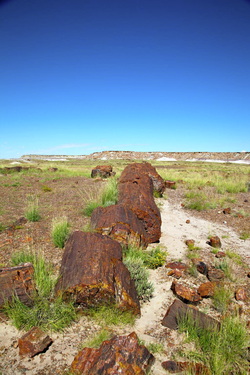 Petrified Forest National Park
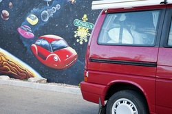
We continued along Route 66 today. Our first stop was Winslow, Arizona. There really isn't much to see in Winslow. It is one of the many small towns in this part of Arizona that were built up during the heydey of Route 66. However, we planned to make a brief stop at the corner of Route 66 and Kinsley Ave, where there is a mural that depicts the scene in the Eagle's song "Take It Easy" - "Standing on a corner in Winslow, Arizona such a fine sight to see..."
When we arrived, the downtown area was closed off for a vintage car show. The 50's music was blasting and the street was lined with vintage cars and what was probably the entire population of Winslow. We ended up spending some time enjoying the cars and the festive atmosphere. Then we took our picture at the corner and were on our way.
The country we drove through today was flat. There was nothing but sky and sage brush. The towns we drove through have seen better days. There does not seem to be much to sustain them other than the few tourist dollars that they attract through selling Route 66 souvenirs. Although the I-40 is a busy trucking route (there are more trucks than cars on the road), the truckers do not stop in the towns. There are huge truck stops that provide services for the big rigs.
As we approached the eastern border of Arizona, the landscape changed from sagebrush to grasslands. It looked as though it would be suitable for ranching, but we saw very few cattle. Water scarcity could be a factor.
We spent several hours exploring Petrified Forest National Park. The petrified trees date back 225 million years to the Late Triassic Period. The area was named the Painted Desert by Spanish explorer, Francisco Vasquez de Coronado, because of the colours in the rocks. The badlands have layers of blues, purples and grays in some areas and in others the rocks are a brilliant red. The plants add colour as well: the greens of the grasses and sage and yellow, gold and white flowers. It was absolutely beautiful.
When we crossed into New Mexico, the landscape changed immediately from high grassland to mesas. We are staying in Gallup for the night and hopefully will have time to explore the town a bit in the morning.
Trip mileage: 3420 miles
 Painted Desert  West of Gallup, NM
 Near Golden Valley, AZ  Morning rainbow near Kingman, AZ When we set out at 5:30 a.m. the temperature was 90 F. However we gained altitude as we headed east and once we hit the high desert, the temperatures were in the mid 80's. We crossed over into Arizona and Mountain Standard Time this morning. Arizona is the only western state that does not observe daylight saving time.
We stopped in Flagstaff for a short while, and walked through the historic old section of town before continuing on to Walnut Canyon National Monument, which is just 10 miles east of Flagstaff.
Walnut Canyon is the site of cliff dwellings and pueblos where the Sinagua people lived 800 years ago. They made their living by farming on the canyon rim, hunting deer and small game and gathering plants and berries. We walked the interpretive trail which took us through some of the dwellings and the six plant life zones in the 185 feet between the canyon rim and the bottom of the canyon. The Sinagua used the plants for food, medicine, dyes, materials for tools and building materials. Elevation at the canyon rim is nearly 7 000 ft.
We found a nice camp spot near Meteor Crater. This is the site of a huge meteor impact about 50 000 years ago. The crater is 550 feet deep, 2.4 miles in circumference and nearly one mile across. We didn't visit the actual crater.
It has been interesting to meet other RV'ers this trip. We have been surprised by the number of people who live full time in their RV. We met a couple here who sold their home nine years ago and have been on the road since then.
Trip Mileage: 3240 miles  Flagstaff street sign  Walnut Canyon National Park
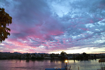 Sunrise over the Colorado River We got up early to photograph the sunrise. Before it got too hot, we walked over to the outlet mall and did some window shopping. The forecast high for today is 105 F. We tried our hand at Keno and won $67.00: we are going to quit while we're ahead. Tomorrow we are bound for Flagstaff. 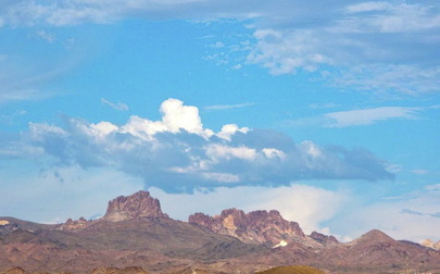 Evening sky from Laughlin 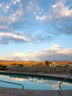 Sunset from the Golden Nugget pool
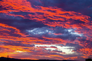 Sunrise Desert Hot Springs, CA We were up and en route early this morning in hopes of beating the heat. In return for our effort we did have a couple of hours of relatively cool driving and we watched a colourful sunrise over the desert.
We drove across the Mojave Desert today, and it was HOT. It was also very lonely. I kept checking for call boxes. They were five miles apart and I calculated that including the melted ice in our cooler and the club soda, we had enough water that we might be able to walk that far and live. It was a big relief when we passed a cell phone tower.
For a few miles, we also drove on Route 66. We got our kicks and saw our first roadrunner of the trip.
We are staying at the Golden Nugget, in Laughlin. As a new member of the casino Gold Card Club, I received a credit for $10 in the casino., which we quickly deposited in the slots.
The casinos are located along the Colorado River. There is a pedestrian walkway along the river. Once it cooled down to about 90 F, we went for an evening walk. The river supports a variety of wildlife: we saw ducks, fish, bats and skunks.
Trip mileage: 3010 miles
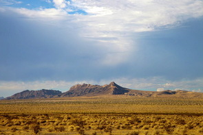 Between Palm Springs and Laughlin
|


 RSS Feed