We enjoyed our drive today. It was very windy in the delta area when we set out this morning.
It must be a typically windy area, as we drove by large fields of windmills, all of which were working.
We are noticing some signs of the struggling economy here in California. In one town both the Ford and Chrysler dealerships were closed and we saw empty storefronts in several towns.
The road took us along the north shore of San Pablo Bay, which is a northern arm of San Francisco Bay, and then into the hills. We were just south of the Napa Valley area so we didn't take in any wine tasting tours. We are, however, drinking Pinot Noir during this part of our trip.
We are staying in an RV park just outside of San Francisco. It is a five minute walk to the ferry terminal. It will be very convenient to take the ferry over to San Francisco. We are planning to head over and spend the day in San Francisco tomorrow. The Moon Festival is going on this weekend in SF.
Trip mileage: 1972 miles
 Brannan Island Marina  Brannan Island, sunset  San Francisco waterside mailboxes 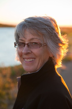 Nancy
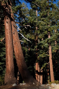 Yosemite Redwoods in morning light We were on the road early this morning in order to try and catch the morning light on the first views of Half Dome which can be seen from the road. As we drove through the meadow area we saw herds of deer grazing in the morning light. Then we made our way down from the mountains to sea level. We could feel the air soften and moisten as we approached the coast. We drove through the central valley which is productive land. There were fields of ripe tomatoes with the workers out picking. We saw our first palm trees, olive trees, orchards of fruit trees as well as vineyards and field of corn.
The area where we are staying is a delta of the Sacramento River. The boats which are in the marina across the road have access to San Francisco Bay.
Trip Mileage: 1894  San Pedro Reservoir
We spent a long, restless night partly because we went to bed too early. It was also partly due to the fact that our camper was not nearly level. The upside, however, was that we were able to spend time gazing at the millions and millions of stars. They were incredibly bright. There is no electricity in the campground, not even in the washrooms so there was no ambient light to detract from the stars.
The drive to Yosemite is about 90 minutes. The road winds and descends through redwood forest. Since Bob was here a couple of years ago there has been a major forest fire and much of the forest was completely burned.
When we came around the corner into Yosemite my heart actually skipped a beat. I thought of the words of Edna St. Vincent Millay.
O WORLD, I cannot hold thee close enough!
Thy winds, thy wide grey skies!
Thy mists that roll and rise!
Thy woods, this autumn day, that ache and sag
And all but cry with colour! That gaunt crag
To crush! To lift the lean of that black bluff!
World, World, I cannot get thee close enough!
…… Lord, I do fear
Thou’st made the world too beautiful this year
My soul is all but out of me.
The peaks are so big and so close that it took awhile to figure out the perspective. The valley floor is grassy meadow and forests of redwood, pine, poplars and giant oak trees. We learned that acorns provided an important staple for the natives in this area. They also traded acorns and obsidian with other tribes from the west.
We parked our van and used the excellent shuttle system to go from one point of interest to the next in the park. Each spot provided a photo opportunity. We watched climbers on Lost Arrow Spire and on El Capitan. There was a disabled climber making an ascent on El Capitan. He had a support team going ahead to set ropes, and then he was jumaring himself up with one arm. When we saw them they were about one day from completing the climb.
The temperature went up to 84 today and this evening feels a bit warmer than yesterday. We lit a campfire so that we can sit out a bit longer this evening. The park does not require a fire permit, but you have to purchase the firewood from them. It comes in a box complete with kindling for about $8.00. We are surprised with how clean the wood is and how long and hot it burns.  Half Dome reflected in Merced River  Lost Arrow Spire at Top Left 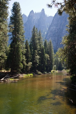 Cathedral Rocks  El Capitan  Half Dome from Olmsted Point  Nancy at evening fire
We took advantage of our high elevation and clear skies to do some star gazing last night. Bob experimented with photographing the stars, which hopefully will turn out well. It did drop down to freezing so we were glad to have our little electric heater to take the chill off this morning. Once the sun got up, however, it soon warmed.  Star Trails, Bridgeport Lake  Mono Lake There were many more birds on the lake this morning. We saw a large number of Pelicans as well as some White Faced Ibis. This must a destination for migratory birds.
This reservoir seems to be a very popular fishing spot. Most of the other campers here are fisherman and they were out on the lake at first light this morning.
The drive to Tuolumne Meadows was scenic. We stopped briefly at Mono Lake which has some large stone formations along the shoreline. It would have been interesting to have had more time to explore there. Ruby made a heroic effort to get up the steep and twisty eleven mile Tioga Pass to the Yosemite Park Gates. The elevation at the summit of the pass is 9945’ Tuolumne Meadows is at about 8680’. After setting up our camp, we walked through the meadows to Parson’s Lodge and then went a little way along the Hetchy Sketchy Trail. The views in every direction were spectacular. Bob was in photographer’s heaven.
Trip mileage: 1604 miles  Tuolumne River  Parson's Lodge interior  Parson's Lodge  Lembert Dome, Tuolumne Meadows
We headed south from Susanville this morning. At Reno we stopped for a couple of hours to wander through the casinos and see the sights. Bob stayed at the Eldorado a few years ago when he was there for a curling bonspiel. He was interested to pay a revisit. After losing a few dollars at the slots we ate at the buffet and then set out for Bridgeport. 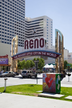 Reno, Nevada Towards Bridgeport we entered the Sierra Nevada Mountains. The road climbed up a narrow, rugged valley. The Walker River, which starts just northeast of Yosemite, flows through the valley. The river is named for Joseph Walker, who led wagon trains through this route during the 1840’s. We could only imagine how difficult that must have been. What took us a couple of hours, would have taken two months for the wagon trains 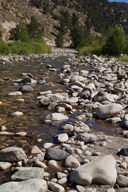 Walker River The Walker River has been dammed to form the Bridgeport Reservoir. Bridgeport is a small town on the edge of the reservoir. The elevation is over 6500’. Although it was very warm during the day (mid 80’s F), we expect that it could get cold during the night. We are camped on the edge of the reservoir overlooking the mountains.
Trip mileage: 1556 miles  Sierra Nevada from Bridgeport Lake  Bridgeport Court House
 Klamath Basin Wildlife Refuge Today ended up a bit longer than we had planned due to what I still maintain were only minor navigational hiccups. We arrived in Susanville around 5:30, and the van is washed and the contents have been shaken out and wiped down, so we are ready to relax now.
Our first stop this morning was the Klamath Basin National Wildlife Refuge, a few short miles south of Klamath Falls and just over the border into California. Historically, this basin area was filled with 185,000 acres of lakes and freshwater marshes. The area was an important staging area for migrating birds during all four seasons. At the peak of the fall migration there were as many as 6 million waterfowl here.
 Petroglyph Point In 1905 the lakes and marshes were drained to support agriculture. In 1908, Lower Klamath Refuge, which is the first of six waterfowl refuges in the area, was established. During the peak of the fall migration in November, the number of birds can reach over 1 million. There is a 10 mile auto tour around the refuge, which we took. The road was gravel and very dusty. There were thousands of birds on the marshes. We saw pelicans, White-faced Ibis, Canada Geese, Mallards, Herons and countless duck species that we couldn't identify. There were also hawks and what looked like turkey vultures. This would be a good destination for birders. You would need to set up a blind if you wanted to do serious photography, as the birds moved away as soon as they saw the car approaching.
At the end of the marsh loop we experienced our first route finding "hiccup". We had planned to carry on to the visitor centre at Lava Beds National Monument, however we ended up at Petroglyph Point, one of the interpretive stops on the road that winds through the monument area. The site is a large bluff or hill that rises out of the surrounding basin area. It was formed about 300,000 years ago when the area was covered by Lake Modoc. Volcanic magma welled up from the bottom of the lake and fell back down to the bottom of the lake. Layer upon layer of magma formed the hill. Modoc lake eventually receded, leaving a number of smaller lakes in this area, including Tule Lake.
The first humans in the area approached the cliff by canoe and created the petroglyphs along the bottom of the cliff. Researchers have not been able to determine if there is any significance to the images and consider them to be rock art.
 Mount Shasta from Captain Jack's Stronghold Lava Beds National Monument is a vast area which contains a number of interesting geological features such as lava tubes and caves as well as some points of historical significance. It was the site of the Modoc War. Our second "hiccup" brought us to Captain Jack's Stronghold, an area in the desert where a group of 50 Modoc warriors, and their women and children managed to hold off the American army for five months in an attempt to retain their native homeland. At that time Tule Lake came up to the edge of the area where they were defending their position from amongst the lava formations. We did a short hike through the area. There is information on the Modoc and the history of the area at the Lava Beds National Monument website.
We did finally arrive at the visitor centre for Lava Beds National Monument, but we couldn't find the way back to the main highway. Earlier in the day, we met a couple from Washington, DC, at the Klamath Basin National Refuge Visitor Centre. They are doing a long road trip as well. We shared a chuckle about living in close quarters for an extended period of time and how most arguments have to do with navigation. We met them again at the Lava Beds Visitor Centre. They, like us,were trying to find their way out of the monument area. We consulted with the visitor centre girl, got our maps out and turned them this way and that and eventually all agreed on the route to take. We said our goodbyes, jumped in our vehicles and headed out. Ten minutes later, we met up again, approaching from opposite directions. We all admitted that we didn't have a clue where to go. They decided to follow the road that was marked as closed in 9 miles. We decided to backtrack the way we had come in. We made it to Susanville and hope they did as well.
Susanville is a nice little city located in the desert hills. Enroute we saw antelope grazing in the sage brush and we saw what we thought were buzzards circling over a spot in the desert.
Trip mileage: 1370 miles
 Eagle Lake North of Susanville, CA
We stayed put today. We wanted a day to tend to the laundry, organize photos and get a start with our blog. Temperatures went up to 85 F and outdoor living is a pleasure. We took the bus into downtown Klamath Falls this afternoon. In comparison to the bustle and traffic in Sisters, Klamath Falls is quiet. The few shops and restaurants that were open downtown were not busy. There are some attractive historic buildings.
Trip mileage: 1110 miles
 Mount Washington Although it went below freezing during the night, the weather has improved. Skies were clear and blue this morning and once the sun came up it quickly warmed up to the mid 20's C. We were happy to sit outside with our morning coffee and soak up the warmth.
We spent the first part of the day driving the McKenzie Scenic Highway, which is an 80 mile loop in the Willamette National Forest, beginning and ending at Sisters. The highway climbs through pine forests to Santiam Pass, which affords good views of Mount Washington, Mount Jefferson and the Sisters. The area experienced a major forest fire several years ago, and it is dramatic and beautiful. The Pacific Crest Trail runs through the loop.
 Lava Rock We saw our first lava rock and were surprised at how rough and jagged the rocks are.
 Clear Lake Beyond Santiam Pass the road descended through rain forest. We stopped at Clear Lake before beginning the climb back up towards McKenzie Pass. The road here was narrow and twisty; the trees formed an arch above us. The speed limit was 35 mph or less, fast enough with the narrow road and twisties. There were few open views until we suddenly emerged at Belknap Crater, a landscape of black lava - very rough, with deep fissures and cracks.
 Three Sisters Further along we came to a dramatic view of the Sisters against a lava field foreground. The contrast between the black lava and the snow-covered mountains was spectacular. Years ago, a local forestry worker, Dee Wright, constructed an observatory out of lava rock at the summit of the pass. He designed it so that the windows are aligned perfectly with the various mountain peaks in a 360 degree radius.
After completing the loop we drove south to Klamath Falls, Oregon. It is a small city situated in a basin surrounded by desert hills. The Klamath National Wildlife refuge is in this area. As we drove by Upper Klamath Lake we saw flocks of pelicans and other migratory birds .
Trip mileage: 1110 miles
 Pacific Crest Trailhead
The wind died during the night, but it was cold. This morning we were reminded of the sweet smell of sage that we associate with Redmond. Unfortunately, the wind picked up again, and although the skies were clear, and it was pleasant in sheltered spots, it was chilly. We drove a short distance to Sisters, where we are staying at a KOA campground.
Sisters is a quaint tourist town. The shops are geared to tourists and the slogan is "Welcome to the Charm Trail". The country around Sisters is beautiful. It is desert and the sagebrush is blooming bright yellow. There are enormous Ponderosa Pines and on the horizon are the Cascade mountains with the volcanic domes of three Sisters and Mount Jefferson dominant. Today the mountains were shrouded in cloud, and we only caught glimpses as the clouds moved in and away.
The area seems very prosperous. There are small ranches with llamas, sheep and horses grazing in the fields. The homes are big and expensive looking.
Although we cooked outside this evening, it is still too breezy to sit outside in comfort. Bob wore my tuque while he was cooking. We are becoming a bit impatient for warmer, camper friendly weather.
Trip mileage 835 miles.  Three Sisters from Sisters
 Near Ritzville, WA Our route to Redmond took us through Priest River and Spokane. Just outside of Ritzville, I became distracted by the huge dust devils that were forming in the fields, and let my navigational duties lapse. We were 50 miles west on the wrong road before Bob realized it. Fortunately, we were able to take a connecting road south from Moses Lake through Othello and joined up with our intended route at Mesa. In the long run, it turned out that we went through some new and beautiful country. And, as I reminded Bob; it is the journey, not the destination that is important.
Although this is desert, with the benefit of irrigation, the land yields rich bounty. We went through mile upon mile of thick, green corn, "as high as an elephant's eye". There were acres of orchards; the apples hanging thick and red on the branches and the wooden crates piled up on the side of the fields ready for harvest. There were potatoes and onions. We passed several trucks stacked high with white onions. We also went past vineyards, and could see the workers picking the grapes. Most of the fields were being watered, and there were new crops just coming up, but we didn't know what they were. This small corner of the American economy is certainly productive.
After Kennewick, we branched west along the Columbia river. The river here forms the border between Washington and Oregon. It is rugged, dry country. The river cuts through the desert, but there is no green along the shores as one might expect. I thought of Anne Michael's description of the Nile river in her novel, The Winter Vault. She described the river as a blue vein running along a pale forearm. It was interesting to see how big and majestic the Columbia River is here compared to when we crossed the headwaters at Canal Flats. There were some tugboats pushing barges up river. We weren't sure what they were transporting, but wondered if it would be aluminum from the John Day mine which is just above the gorge. We stopped at Maryhill State Park, a green oasis right at the Columbia River Gorge, to watch some windsurfers on the river.
This is a windy spot, and there were windmills along the hilltops. When we crossed the river and climbed up to the top of the hill on the Oregon side we looked back and were amazed to see mile upon mile of windmills stretching back to the horizon.
We pulled into Redmond just after the sun set. We are camping at the expo grounds, where we came for the BMOA rally in July. It is much quieter here tonight, although the wind is howling through the canvas in our camper and sets us rocking from time to time.
Trip mileage: 787 miles
 Columbia River Gorge  Windmills above Columbia River Gorge
|


 RSS Feed